Biophysical Interactions - Geomorphic and hydrological processes
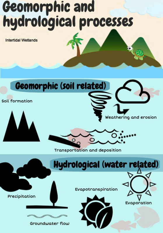
The geomorphological and hydrological processes combine to create intertidal wetlands. The deposition of silt in the lower coastal regions
is essential to the development of intertidal wetlands. Changes to these processes can result in ecosystems being placed at risk
Rising Sea Level – rises and falls in sea level will obviously affect the nature and location of wetlands. The rise in sea level from the last Ice Age has affected the nature, shape and position of coastlines.
Weathering – The intertidal wetland is where large amounts of weathered material accumulate. This alluvial material, and the organic
material from vegetation results in nutrient-rich soils. (the grey mangrove produces 600 tonnes of leaf material per 1 cm squared a year)
Soil formation - The nature of the soil reflects the parent material, topography, climate, and vegetation of the area. They are usually grey in colour; poorly drained and rich in organic matter. The soil often smells strongly of sulfide compounds. Mangroves cope with the unstable nature of the soils by having shallow, widespread root systems. Due to the lack of oxygen within the soil, mangroves have developed specialised structures to facilitate the absorption of oxygen into their root systems.
Erosion – the position of wetlands in sheltered bays makes these areas of accumulation/deposition rather than erosion. The role of wetlands as flood mitigators means that they are able to absorb floodwaters and release them slowly to minimise erosion. However, some erosion will occur after storms and salt marshes may be ‘scarred’ as a result of trampling.
Geomorphic processes (soil related)
Weathering and erosion
- parent, material, topography, climate and vegetation determine soil
- high salt levels in soils make them more susceptible to erosion
- location in sheltered bays results in the accumulation of sediment
- parent, material, topography, climate and vegetation determine soil
- high salt levels in soils make them more susceptible to erosion
- location in sheltered bays results in the accumulation of sediment
Transport and deposition
- sediment received from upper catchment (upstream)
- increased water flow increases the deposition of silt (more silt is carriedfrom upstream)
- speed of water flow sorts sediments (only the finest sediments make it to the estuary)
- sediment received from upper catchment (upstream)
- increased water flow increases the deposition of silt (more silt is carriedfrom upstream)
- speed of water flow sorts sediments (only the finest sediments make it to the estuary)
Soil formation
- decaying mangrove leaves add nutrients to the soil.
- soil is formed from material eroded upstream
- decaying mangrove leaves add nutrients to the soil.
- soil is formed from material eroded upstream
Hydrological processes (water related)
Precipitation
- rainfall alters salinity levels in soils
- rainfall determines freshwater/salinity levels of the water
- rainfall alters salinity levels in soils
- rainfall determines freshwater/salinity levels of the water
Evaporation and evapo-transpiration
- high levels of evaporation
- some trees e.g. mangroves have adaptations to reduce evapo-transpiration
- high levels of evaporation
- some trees e.g. mangroves have adaptations to reduce evapo-transpiration
Groundwater flow
- mangrove trees aid in flood mitigation
- vegetation near the river, bay or coastline filters water before entry into the main water body
- mangrove trees aid in flood mitigation
- vegetation near the river, bay or coastline filters water before entry into the main water body
